Transportation Authorities are continually challenged to provide and maintain a safe and efficient highway network. Not only are bridges an integral part of the network, they also represent a multibillion-dollar investment. To meet this challenge and safeguard this investment, transportation authorities need to understand completely the condition and behavior of the bridge structures, so that the bridge can remain open to traffic, be resistant to the elements, and be undaunted by the millions of loading cycle per year – all with minimal maintenance expense.
Realistically, the high cost of maintenance – often exacerbated by the budget-driven policies of bridge owners – frequently leads to the deferment of routine bridge repairs and reservation measures. These policies can contribute to an occasional bridge failure, which is completely unacceptable and forces more costly actions. To manage bridges effectively, more needs to be done to access the day-to-day and long-term condition and behaviour of in-service bridges, so that preventive measures can be taken, and deterioration rates can be better understood.
Owing to the advantages of high accuracy, all-weather conditions and no requirements of inter-visibility between measuring points, GNSS, the acronym standing for Global Navigation Satellite System and including the US Global Positioning System, GLONASS its Russian equivalent, the future European GALILEO and the Chinese BEIDOU (Big Dipper) is playing more and more important role in high precision positioning missions in structure/construction health monitoring.
For achieving a particular purpose, a properly configured GNSS measurement system can meet most of the possible static and dynamic measurement needs in such applications for absolute positioning and relative displacement. In other words the required precision and accuracy can be approached with an architecture of the GNSS single/dual (L1 or L1/L2) frequency carrier phase, data sampling rate, communication between GNSS receivers and control data centre and the method of data processing.
GNSS is a very interesting tool for monitoring because it has a number of distinct advantages over terrestrial positioning technologies. GNSS is able to measure at high rates with low latency, operate in all weather conditions, has synchronized measurement, does not require line of site to ground marks/targets, can measure over long baselines, has low maintenance and a long service life and can provide timing for other sensors, such as accelerometers. These unique characteristics make GNSS particularly interesting for monitoring large structures such as long bridges, dams, high rise buildings but also for seismic and land slide applications and for the provision of control for other instruments, such as robotic total stations, in unstable areas. Each point to be measured must have an antenna, a receiver, ground mark, power, communications and, possibly, protection against lightning and vandalism or theft.
The reference stations receivers from where the baseline to the monitoring receivers will be processed must be installed in a stable place as all the results will refer to this. The minimum required is only one but to ensure an independent control on the solution and to have also an internal control on the relative stability of their location it is suggested to set-up at least two. As in Wallonia the SPW is offering the correction service (Network RTK), CGEOS is using that facility to deliver the highest accuracy without the need of local base stations.
In monitoring applications, accuracy is of paramount importance, so only ambiguity-fixed positions are of interest. A highly reliable ambiguity resolution strategy is needed to prevent wrong fixes, which will be detected immediately by the monitoring system as an apparent movement. The processing kernel that has been developed for the bridge GNSS monitoring solution is based on the RTK-LIB, an open source software developped by Mr Takasu from Japan that most of the scientific institutions are using nowadays. Open Source Software solution is a must for governmental projects in Europe.
Due to the nature of the different sources that affects the solution of GNSS measurements like the atmospheric delays, the orbital errors and the multi-path effects in some extend, the results are generally noisy and will not reflect at first look the full potential of the solution.Therefore it is necessary to reduce the noise by using digital signal processing filtering techniques. CGEOS developps and tunes such filters that have that capacity and various tests have demonstrated that up to 30% to 45% of the noise are effectively reduced.
The ability to monitor real-time data from a remote location is a critical issue due to the divergence often found between the location of structures and the location of the people charged with monitoring those structures.
CGEOS - Creative Geosensing, the Wallony based geodetic engineering company can provide GNSS monitoring systems that gather the data and feed it to a remote location via the Internet to give you 24/7 monitoring capability from any location. Whether the movement occurs over a period of seconds, minutes, hours, days, weeks or months, the system offered by CGEOS is able to track the movement. Parameters can be set such that any movement outside a designated range can automatically notify the responsible people. This timely information gives the operators time to take an appropriate response and avoid any critical failures. Even more important is to map the positioning information into the frequency domain and to deliver the bridge engineers the frequencies they are looking for.
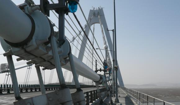
Joël van Cranenbroeck, Managing Director of CGEOS, has introduced succesfully and for the very first time in Europe, GPS for monitoring bridge loading tests starting with the Val Benoit bridge in Liege end of November 1999. Since then, CGEOS has been involved in the large bridge monitoring project worldwide such the Tsi Ma Bridge in Hong Kong, the Yeong Jong bridge in Seoul and many other bridges in China but also the Bridge of Normandy and the bridge of Tancarville in France. If Belgium and Wallonia are well known by bridge engineering designers and experts they have, CGEOS is adding the most advanced GNSS monitoring system to these prestigious infrastructures. Last not least, with the today performances of GNSS receivers, CGEOS is aiming to introduced that technology for medium and small bridges as well working on that topic with the University of Nottingham Ningbo in China.
CGEOS would be very pleased to bring its expertise for succeding your monitoring projects.


CTA
Sign up
Complete the application form and adhere to the Charter of Brand Ambassadors